For information on how to run the code see the readme: https://github.com/ucgmsim/Empirical_Engine/blob/master/README.md
Conceptual Model
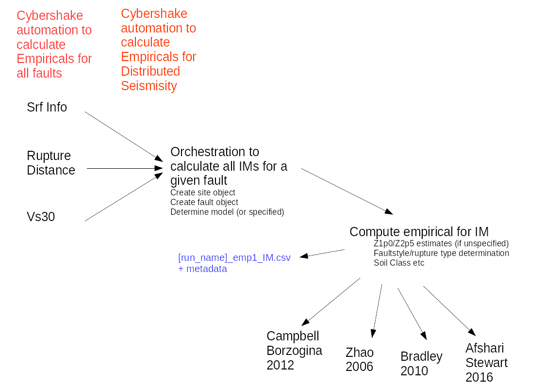
Models
| Model Name | Year | Shorthand | IMs Calculated | TechtonicType |
|---|---|---|---|---|
| CampellBorzorgina | 2012 | CB_12 | AI | ACTIVE_SHALLOW |
| CampellBorzorgina | 2010 | CB_10 | CAV | ACTIVE_SHALLOW |
| Bradley | 2013 | BR_13 | PGA, PGV, pSA | ACTIVE_SHALLOW, VOLCANIC |
| AfshariStewart | 2016 | AS_16 | Ds575, Ds595, Ds2080 | ACTIVE_SHALLOW |
| Zhao | 2006 | ZA_06 | pSA (interpolated above 5.0s), PGA | ACTIVE_SHALLOW, SUBDUCTION_INTERFACE, SUBDUCTION_SLAB |
| AbrahamsonSilvaKamai | 2014 | ASK_14 | PGV, PGA, pSA | ACTIVE_SHALLOW |
| BC_Hydro | 2016 | BC_16 | PGA, pSA | SUBDUCTION_INTERFACE, SUBDUCTION_SLAB |
| BooreStewartSeyhanAtkinson | 2014 | BSSA_14 | PGV, PGA, pSA | ACTIVE_SHALLOW |
| ChiouYoungs | 2014 | CY_14 | PGV, PGA, pSA | ACTIVE_SHALLOW |
| McVerry | 2006 | MV_06 | PGA, PGV, pSA (interpolated above 3.0s) | ACTIVE_SHALLOW, SUBDUCTION_INTERFACE, SUBDUCTION_SLAB |
Site Parameters Needed
| Parameter | Description | BR_13 | AS_16 | CB_12/CB_10 | ZA_06 | ASK_14 | BC_16 | BSSA_14 | CY_14 | MV_06 |
|---|---|---|---|---|---|---|---|---|---|---|
| Rrup | Source-to-site distance (km) (Rrup distance) | ✓ | ✓ | ✓ | ✓ | ✓ | ✓ | ✓ | ✓ | |
| Rjb | ✓ | ✓ | ✓ | ✓ | ✓ | |||||
| Rx | distance measured perpendicular to fault strike from surface projection of updip edge of the fault rupture (+ve in downdip dir) (km) | ✓ | ✓ | ✓ | ||||||
| Ry | ✓ | |||||||||
| hw | Flag for sites on the hanging wall | ✓ | ✓ | ✓ | ||||||
| Rtvz | source-to-site distance in the Taupo volcanic zone (TVZ) in km | ✓ | ✓ | |||||||
| Vs30 | ✓ | ✓ | ✓ | ✓ | ✓ | ✓ | ✓ | |||
| Vs30measured | If the vs30 measurement is taken from a ____ True otherwise False | ✓ | ✓ | ✓ | ||||||
| siteclass | determined from vs30 'hardrock';'rock';'hardsoil';'mediumsoil';'softsoil' (also called siteType)
| ✓ | ✓ | ✓ | ||||||
| Z1p0 | Can be estimated from vs30 | ✓ | ✓ | ✓ | ✓ | ✓ | ||||
| Z2p5 | Can be estimated from vs30 | ✓ | ✓ | |||||||
| backarc | Flag for if the site is on the backarc or forearc. Defaults to false. |
Fault Parameters Needed
| Parameter | Description | BR_13 | AS_16 | CB_12/CB_10 | ZA_06 | ASK_14 | BC_16 | BSSA_14 | CY_14 | MV_06 |
|---|---|---|---|---|---|---|---|---|---|---|
| Mw | Moment magnitude | ✓ | ✓ | ✓ | ✓ | ✓ | ✓ | ✓ | ✓ | ✓ |
rake | rake angle | ✓ | ✓ | ✓ | ✓ | |||||
| dip | dip angle | ✓ | ✓ | ✓ | ✓ | |||||
| ztor |
| ✓ | ✓ | ✓ | ||||||
| rupture_type | (reverse, normal, strikeslip, oblique, unknown) This is currently estimated by Reverse <- 45 < rake < 135; Normal <- -135 < rake < -45; StrikeSlip <- 0 < abs(rake) < 45, 135 < abs(rake) < 180, | ✓ | ✓ | ✓ | ✓ | |||||
| tect_type | (active_shallow, volcanic, subduction_interface, subduction_slab) | ✓ | ✓ | ✓ | ||||||
| hdepth | focal depth (km) (hypocentral depth) | ✓ | ✓ | ✓ | ||||||
| width | down dip rupture width | ✓ | ||||||||
| as | flag to indicate aftershock (defaults to False) | ✓ |
Folder Structure
TBD
File Structure
IM_file