This page has descriptions of the file formats that we use in various places.
| Table of Contents |
|---|
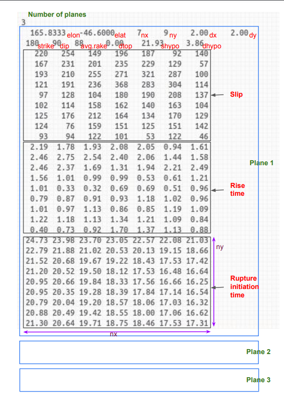
SRF Format
- https://strike.scec.org/scecpedia/Standard_Rupture_Format
- SRF-Description-Graves_2.0.pdf
- SRF File Format Version 1 (output of genslip): srf_description_version_1.pdf
- Details on Source Modelling : Source Modelling for GMSim
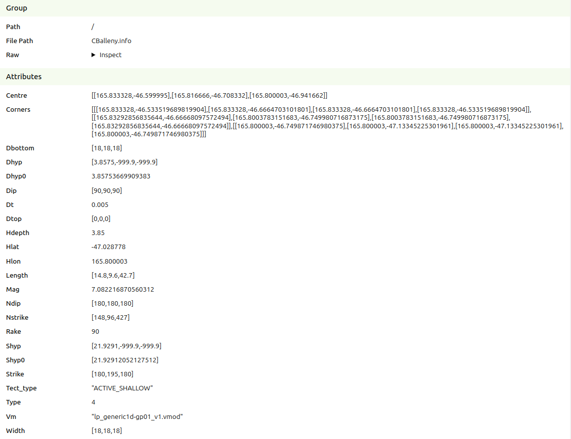
SRF info format
The .info files that accompany .srf files are in HDF5 format
Example (CBalleny.info)
Stoch format
LF/HF/BB binary format
These files store timeseries data. All formats follow a style derived from the LF seis format produced by EMOD3D:
...
HF and BB have gaps between the first 2 sections to allow future additions to section 1 without breaking backwards compatibility.
| LF | HF | BB |
|---|---|---|
i4 number of stations TOTAL 4 BYTES | i4 number of stations
i4 number of ray methods
i4 first ray method used TOTAL 288 BYTES | i4 number of stations TOTAL 788 BYTES |
START OFFSET 4 BYTES i4 index of station in input file TOTAL 48 BYTES * NUM_STATIONS | START OFFSET 512 BYTES f4 longitude of station (degrees) |
m/s) TOTAL 24 BYTES * NUM_STATIONS | START OFFSET 1280 BYTES f4 longitude of station (degrees) |
vs30ref ( |
m/s) |
vs30ref ( |
m/s) |
m/s) TOTAL 44 BYETS * NUM_STATIONS | ||
START OFFSET 0 FROM ABOVE f4 velocity (cm/s) timeseries in array dimensions: TOTAL 4 BYTES * PRODUCT_OF_DIMENTIONS | START OFFSET 0 FROM ABOVE f4 acceleration (cm/s^2) timeseries in array dimensions: TOTAL 4 BYTES * PRODUCT_OF_DIMENTIONS | START OFFSET 0 FROM ABOVE f4 acceleration (g) timeseries in array dimensions: TOTAL 4 BYTES * PRODUCT_OF_DIMENTIONS |
XYTS.e3d binary format
This file is produced by EMOD3D and contains a timeseries of ground motions on the XY plane. Unlike the LF seis files, this contains data at all grid points and may have a decimated resolution specified when running EMOD3D through the e3d.par file with the parameters dxts and dyts.
...
- simulation metadata
- INTEGERS
- number of first x gridpoint
- number of first y gridpoint
- number of first z gridpoint
- number of first timestep
- number of x gridpoints
- number of y gridpoints
- number of z gridpoins (always 1 by definition of X-Y file)
- number of timesteps
- FLOATS
- x spacing between given gridpoints (km)
- y spacing between given gridpoints (km)
- original (pre-decimated) grid spacing between gridpoints used in simulation (km)
- timestep in timeseries (s)
- model rotation of gridpoints (degrees)
- model centre latitude (degrees)
- model centre longitude (degrees)
- x spacing between given gridpoints (km)
- INTEGERS
- timeseries
- float array of velocities in the dimentions of timesteps, components (x, y, z), y grid positions, x grid positions.
Intensity Measure calculation
The IM calculation code will produce a number of text files (decided as of 25/05/2018). We will summarize them in the following.
...
The aggregate one has all the stations on a single place:
| Code Block |
|---|
station, component, IM_1, IM_2, ...., IM_N |
Empirical IMs
As above the empirical intensity measures have a similar format:
| Code Block |
|---|
station, component, IM_1, IM_1_sigma, IM_2, IM_2_sigma, ...., IM_N, IM_N_sigma |
Notes: 1) the component for empirical IMs is always 'geom' 2) only total sigma is saved to the csv file
Rrup file
The file format for this is:
...